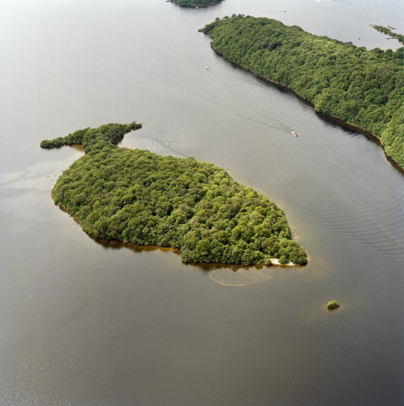
The Island of Clairinch – The Heart of the Clan – Clar Innis
Clairinch – the Heart of Clan Buchanan
It is generally believed that Clairinch was the first land in the district in possession of the Buchanan Chiefs in 1225 and, as such, became the “Heart of the Clan.”
Absalon, the grantee in the 1225 charter of Maldouen, Earl of Lennox, was the ancestor of the Clan Buchanan. Under the designation of seneschal of the Earl of Lennox, his name appears as a witness to various charters. Absalon and his sons Gilbert and Matthew were witnesses to a charter granted by Maldoune, earl of Lennox, to Gillemore, son of Maldouen, of the lands of Luss.
Clan history tells us that Anselan/Absalon had three sons. Gilbert the eldest who first assumed the name of Buchanan. Methlin (Matthew) the second son was the ancestor of the MacMillans and his third son, Colman, the ancestor of the MacColman family. However, the clan Y-DNA project shows no clan relationship with the Clan MacMillan.
In 1681, Clairinch passed from Buchanan hands to the estate of the Marquis of Montrose at the time of the dissolution of the estate of John Buchanan, the last chief of Clan Buchanan.
Clairinch became the slogan or war-cry of the Clan Buchanan, “Clar Innis,” and, in times of peril, the fighting men of the Clan Buchanan used to gather on the Island – well-armed for attack or defence.

Lady Buchanan and Kim Tuovinen (CBSI archaeology leader) visit ClairInch via kayak
Royal Charter for Clairinch and The Kitchen
The island of Clairinch was held by the Clan Buchanan under Royal Charter, and each new Laird renewed this charter. The charter was granted in 1225 to Anselan/Absalon, third of that name and 7th Laird of Buchanan, the son of MacBed, and his heirs by Malduin/Maldouen, 3rd Earl of Lennox, for the rent of one pound of wax each year. It was witnessed by Dougal, Gilchrist and Amelyn, brethren of the Earl.
The following is a translation of this charter:
Maldouen, Earl of Lennox – to all his friends and man, present and to come, Greetings:
Know ye that I have given, granted, and by this my charter have confirmed to Absalon, son of MacBed, that Island which is called Clairines: To be held by him and his heirs of me and my heirs in fen and heritage, with all its pertinants and easments, freely, quietly, fully, and entirely, without any secular or servile exaction: the reddendo to me and my heirs, by him and his heirs, being each year, for all services, customs and exactions, one pound of wax at the nativity of our Lord:
Witnesses, Dunegal, Hamel, Duncan, Malcolm Gilchrist, my brothers; Malcolm Beg; Adam, son of Morin; William, son of Bede; Simon, chaplain; Gilbert, clerk; Patrick, son of Malbride; and others; given at Clarines, in the year of grace 1225.
The charter was confirmed by King Alexander the Second by a charter dated at Linlithgow on the 6th of September, and in the seventeenth year of his reign (1231 ), and at the same time granted the licence of fishing in his lake of “Lochlomne”.
In 1564, Sir George, second of the name and 16th Laird of Buchanan, was granted a charter in his favour by King Henry and Queen Mary of lands of Buchanan, “Ifles of Clareinch and Kepinch. with bell and alms of St. Keffig.” (this was the period when Mary Queen of Scots and her husband Henry Stewart – Lord Darnley were enthroned).
In the 17th century, “Sir John, 17th Laird of Buchanan, appears by Charter in his favour of King James VI, in the lands of Buchanan.” [King James VI/ I – (1566 – 1625 ) was the son of Mary Queen of Scots and is famed for uniting the two crowns of Scotland and England.]
The Clan’s War Cry - “Clar Innis!”
Clairinch was the historical gathering place in a time of trouble for the Clan Buchanan. in time, Clairinch became the Slughorn or Call of War proper, “Clar Innis,” to the Clan Buchanan. Such a system of a call being used by a large number of families in those early times. As soon as this call was raised – upon any alarm where the Clan or its interest were concerned the word was sounded aloud from one to another, so that in a very short time all the effective men belonging to the Clan Buchanan, did with utmost diligence repair well armed to the ordinary rendezvous, which when the Laird resided upon the Island, was upon the shore of the Loch opposite Clairinch.
In a later period, the Slughorn call was replaced by the Firecross, being a small stick in the form of a cross, blackened with fire at its extremities. This Cross, once set going, was carried through to each family with great despatch and in a short time would alarm people over a vast extent of land.
“A slender crosslet, form’d with care,
A cubit’s length in measure due,
The shaft and limbs were rods of Yew,
Whose parents in Inch-Cailloch wave
Their shadows o’er Clan Alpine’s grave,
And, answering Lomond’s breezes deep,
Soothe many a chieftain’s endless sleep.
Fast as the fatal symbol flies,
In arms the hits and hamlet rise,
From winding glen, from upland town,
They pour’d each hardy tenant down”
Loss of Clairinch and The Kitchen to the Marquis of Montrose (Clan Graham) in 1681
Sir John Buchanan, 20th Laird of Buchanan, was responsible for the loss of Buchanan lands by his extravagant lifestyle and frequent foreign travels. He died in 1681 and his estate was purchased by James, 3rd Marquis of Montrose. This purchase included the Island of Clairinch and Keppinch. The Island and crannog remained in the hands of the Graham family (Duke of Montrose ) until the 20th century.
Buchanan’s regain Clairinch and The Kitchen in 1934
In 1934, William George Buchanan, a wealthy Buchanan clansman, purchased Clairinch and Keppinch from the Montrose estate. By this purchase, the heart of the Buchanan Clan passed back into Buchanan ownership and William was named “Laird of Clairinch”. William, who had lived most of his life in Chile, retired to London where he lived at 24 Park Lane. During this period he had drawn up an extensive family tree showing his descent from Buchanan of that Ilk via Thomas Buchanan of Drummakill, third son of Sir Walter Buchanan of that Ilk.
Clairinch and The Kitchen bequeathed in perpetuity to The Buchanan Society in 1939
William died in 1939 and gifted Clairinch and Keppinch to “The Buchanan Society” a Clan charitable organisation based in Glasgow and recognised as the oldest Clan charity in Scotland, where it remains to this day. William’s last will and testament states clearly that he wishes the Island to be used as an animal and bird sanctuary with no shooting allowed. The document is dated 20 May 1940.
In accordance with William’s wishes upon his death, his ashes were spread on the Island of Clairinch. The island was subsequently leased on 2nd May 1954 to Nature Conservatory Council wherein it was agreed to manage the Island as a Nature Reserve. The period of the lease is stated as 25 years.
William George Buchanan never married but descendants of his Chilian family still live in Chile. The last male Buchanan remaining in his family, John Buchanan son of William’s brother, died a few years ago.
William’s father, George Buchanan, had a twin brother William who travelled to New Zealand and married Emma Bock. William and Emma’s family still live in New Zealand. The late George Alexander Buchanan of Dunedin was a first cousin to William. George’s grandchildren, Claude Buchanan, Earl Brown and Lorraine Wilson-Perrot have contributed a good deal of research into the history of the local family and the greater Clan over the years.
Loch Lomond history
Loch Lomond sits on the line between what is known today as the Highland and Lowlands of Scotland. This line was created by a tectonic plate collision in the periods from mid-Ordovician to the mid-Devonian period some 520-400 million years ago. The loch was created during the last ice age when a glacier gouged out the area which is now known as Loch Lomond. Several rocky outcrops resisted the movement of the ice and these form the Islands of Loch Lomond There remain today 60 of these islands of which 23 have been named.
The loch was originally called Loch Leven. The name was changed about 1200 to its present form of Loch Lomond after the local mountain Ben Lomond. The name Leven is however not forgotten and persists as the Leven River which forms the outlet of the loch to the Clyde River. Vikings roamed in this region and in 1093 Magnus ( known as Magnus Barelegs) son of King Olaf of Norway claimed possession of Loch Lomond ( then Loch Leven) by dragging Viking Longboats across the Isthmus at Tarbet from Loch Long to Loch Lomond. King Malcolm ( Malcolm III known as Canmore, King of Scotland 1058 – 1093 ) had decreed that the Vikings could annex any land they could sail their boats around.
In the year 1263, King Hakkon attacked the area, plundering Scottish communities on the islands and along the shores of the loch. They then sailed down the Leven River to the Clyde River where they were caught in a heavy storm that destroyed many of the heavily laden longboats causing severe loss of life to the Viking army. Those who reached shore were attacked by the Scottish army under the command of King Alexander II at the battle of Largs, thus ending further Viking plundering expeditions. King Alexander II ruled Scotland from 1214 to 1249. The Viking raids into the area were short lived and thus we have no Viking place names in the region or near surrounds. In 1621 the Parish of Buchanan was formed by the union of that of Inchcailloch and a detached portion of the parish of Luss containing the lands of the old family of Buchanan.
Geography of the Clan Lands
The greater part of this area is very mountainous with the highest peak being Ben Lomond rising to 3,192 feet above sea level. There are two small lochs in the area – Loch Arklet to the north and Dubh Lochan a small loch near Loch Lomond about two miles south of Rowardennan The Parish of Buchanan lies at the mouth of the River Endrick and is bounded by the river on the south, by Loch Lomond on the west, by the parish of Arrochar on the north, by loch Katrine and the parishes of Aberfoyle and Drymen on the east. It is about eighteen and a half miles long and varies from two and a quarter to six miles in width. The parish was originally called Inchcailloch from the Island of that name in Loch Lomond on which a church formally stood.
The road from the upper end of the village of Drymen leads westward, skirting the boundaries of the castle and crosses the Burn of Mar, about two and a half miles from Drymen. Above this area at one time sat the local church and school. Proceeding up the Burn of Mar one comes across farms well known to the Clan Buchanan – Gartfairn, High Main, Millrowan Wood, Milton of Buchanan, Creitihall, Gartincaber, and Auchmar.
In an upper field of the farm of Creitihall lies the old healing well of St. Maha. A little further on, to the right of the road, lay the manse over looking the lower part of Loch Lomond and further on, about four miles from Drymen, is Balmaha on Loch Lomond.
Beyond Balmaha the road continues up Loch Lomond a short distance from the shore going through the pass of Balmaha which is generally considered to be the separation between the highlands and the Lowlands.
Opposite Balmaha and this coast of Loch Lomond, there are several Islands belonging to the parish of Buchanan. They are Clairinch, Inchcailloch, Eilandarroch, Inchfad, Inchcruin, Bucinch, and Ceardach. Clairinch is about one kilometre long and half a kilometre wide and has an area of about 14 acres. It is covered with wood.
The archeology of Clairinch can be found in a work “Stirling, an inventory of ancient monuments, Vol 2”. Contained therein is a description of the foundations of four buildings discovered on the Island in 1935. One is of an oblong drystone building 37.5 feet by 19 feet and containing what may have been an oven or small corn drying kiln. In another area was found a pin, which could be dated as having been lost between the first century B.C. and the end of the second century A.D. This perhaps indicates that some of the structural remains on Clairinch were occupied in the early Iron Age.
“The Kitchen” Crannog, also known as Keppinch
Close to Clairinch is a small group of stones and boulders called Keppinch. This area is classified as a crannog. It is a well-known site and is unmistakably of artificial origin.
Keppinch may have been used as a council Island for the Clan Buchanan who had at one time their Clan Seat on Clairinch, since 1225. The use of an artificial island as a meeting place during the medieval period is a well known occurrence. Though featureless now, it could be the "ruins of a castle" lying below the loch surface.
A survey of the Clarinich Island, the walkway and associated crannog was carried out in 1935. On the day of the survey, the top of the crannog was above water and there were a number of small trees growing on it. Keppinch is often submerged when the water level of the loch is high. It consists of stones and boulders, not solid rock like a natural islet.
The bottom of this site is clear and the break of the slope between the top and the sides is obvious. On top is an alignment of stones which appears to delineate a rough oval platform in the middle of the site, the outline of what seemed to be a small building.
On the south west side of the site, there is a protuberance that may have been for landing a boat. The water between Keppinch and Clairinch is shallow but there is no evidence of a causeway or walkway between them.
Reference: Canmore: Loch Lomond, The Kitchen


A crannog is a defensive home built about 5000 years ago. The Crannog Centre has reconstructed an example of a crannog in Loch Tay (reference: www.geograph.org.uk)
From information provided by Claude Askel Buchanan, FSA Scot, Herald Emeritus of Clan Buchanan