The District of Strathendrick
The sources of the River Endrick are at the back of the Gargunnock Hills. The Endrick River is formed by the confluence of the Gourlay and Burnfoot burns which unite at a point about four and a half miles south of Kippen, and become then the Endrick. The river then flows in a westerly direction, bounding or traversing the parishes of Gargunnock, Fintry, Balfron, Killearn, Drymen, Buchanan, and Kilmaronock. The last six parishes may be taken as constituting Strath Endrick. The name Endrick is derived from the Gaelic, ‘avon ruadh’, red river, from the colour of the river when in flood.
Source: Chapter XX. The District of Strathendrick, by Colonel Stirling of Gargunnock in "Strathendrick and its Inhabitants from Early Times: An Account of the Parishes of Fintry, Balfron, Killearn, Drymen, Buchanan, and Kilmaronock" by John Guthrie Smith, FSA Scot, 1896
PARISH OF FINTRY
The Parish of Fintry is about six miles long from east to west, and about five miles from north to south. It consists mostly of muirland and hill pasture. The highest hills in the parish are Stronend 1676 feet, Meikle Bin 1870 feet, and Holehead 1801 feet above sea level.
The village of Fintry is situated in the valley of the Endrick, surrounded by hills. Newtown of Fintry, is on the road about three-quarters of a mile to the west of the village. A cotton mill was erected near there by Spears of Culcreuch in 1796 and the hamlet of Newton was built to accommodate the people employed in the mill, who at one time amounted to 260 hands. The mill did not prove a success and is now in ruin.
The Carron river rises in Fintry Parish and for some distance runs parallel to the Endrick, the Carron flowing to the east and falling into the River Forth at Grangemouth, and the Endrick flowing west and falling into Loch Lomond. A short distance below the old ruins of Sir John de Graham‘s castle, which stands on the side of the road between Carron Bridge and Fintry is a fall called the Loup of Fintry, where the Endrick precipitates itself over a height of upwards of 90 feet from the muirland into the valley below.
The road before reaching Fintry crosses the Endrick by a bridge at Gonachan, and there is also a bridge over the Gonachan Burn.
Two miles to the east of Fintry is the Loup of Fintry: a 28.6 m (94 ft) series of waterfalls on the River Endrick which cascades down the Dun hills over a remarkable range of basaltic pillars. These pillars are part of the volcanic range spanning from Stirling to Dumbarton. Coal occurs in several small seams, and in the Dun Hill are beds of red ochre, fire stone, jasper and specimens of zeolite.
Lowp or "Loup" means leap in Scots.
The surrounding volcanic area, including Waterhead Farm, suggests a vast complex with volcanic structures once reaching significant depths/heights (up to 6km) in the area
PARISH OF BALFRON
The parish of Balfron lies below that of Fintry on the north side of the Endrick, by which it is separated from Killearn. It is about eight miles long from east to west and about two miles broad from north to south. There is a good deal of rough muirland in the higher parts. There are no hills of any great height, the highest points being Ballindalloch Muir, 627 feet, and Balgair Muir, 577 feet above sea level.
The geological formation is old red sand-stone, and there is limestone in the parish. the road leads north from Newton of Fintry through Balfron parish to Kippen, crossing the Endrick by a bridge built in 1804. It passes over the Balgair Muir, where an annual cattle market was held.
At Lernock, where there was formerly a toll, a road branches off to the northeast to Stirling, and to the west to Balfron, passing the Old Place of Balgair, uninhabited in the early 19th. century and in all probability is no longer in existence. The house was built in 1721 and was never finished, and indeed the proprietors of Balgair never lived much in it. The old structure was used by squatters, tinkers, and other wanderers. A stone with the date 1721 cut into it was removed and built into the front wall of the house of Mr. John Buchanan who at one time was resident of Easter Hill of Balgair.
A little further on is the Hill of Balgair, which used to be a larger place than Balfron, with a number of cottars and weavers employed, and provided with a public-house and various shops. None of these now exist.
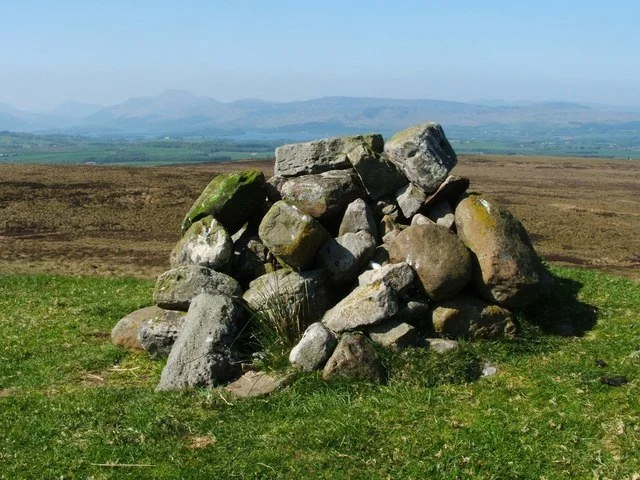
The ‘Highlanders grave’ of Clan McGregor
Near a steep path on the hill face, immediately above the farm of Craigend on the borders of Fintry and Balfron parishes, is a cairn called the Highlander‘s Grave. In one of the raids of the McGregors, the farm of Burnfoot, at the back of the Gargunnock Hills above Fintry, was attacked by about thirty of the clan, and the cattle ‘lifted’. The old farmer, in order to prevent his raising the alarm was tied below the belly of an old mare with his head towards the tail, and nearly choking was carried off with the spoil. When the eldest son of the farmer, who had been away with his brothers helping friends who had been attacked by another portion of the McGregor clan returned, he learned what had happened, and taking his father‘s claymore resolved to have revenge and made after the McGregors at full speed. He came upon them at a place called Skian Dhu, where they were obliged to travel in single file, and striking the hindmost man who had charge of the old mare he rescued his father. The unfortunate McGregor was buried and a few stones were thrown over the grave, as was the custom, and every time they or others passed, another stone was added to the cairn.
A bridge crosses the Endrick at Honeyholm , and a short distance to the north of the road is Edinbellie. In the year 1750 Rob Roy‘s son carried off Jean Kay, then a widow and heiress of Edinbellie, and Rob Oig, the youngest, who had married her, was hanged in Edinburgh three years aferwards on account of her abduction.
One of the Buchanans of Cremanan was shot near an old oak tree which stood by the side of the road passing through Clachan of Balfron, by Rob Roy‘s men. They had intended to shoot Cunningham of Ballindalloch, as it was he who had issued the warrant for the apprehension of Rob Roy‘s son after the abduction of Jean Kay, and they had mistaken their friend Buchanan for Cunningham. Cremanan was a small place above Balfron and is now no longer in existence.
Further on the road passes through the lower part of the village of Balfron and joins the road to Glasgow which crosses the Endrick by the Ballindalloch Bridge.
THE PARISH OF DRYMEN
The parish of Drymen adjoins Killearn and Balfron lower down the Endrick. The name is derived from the Gaelic druimean, a ridge, and from it the family of Drummond take their name, their ancestors in the time of Malcolm Canmore having obtained from him a grant of the lands of Drymen.
The Endrick flows through part of the parish, and seperates it from Killearn for a short distance at the west, and from Kilmarnock at the east end of the parish. It greatest length from north to south is eleven miles, and its breadth from east to west varies from under a mile to about ten miles. The other rivers which bound the parish on the north are Duchray, and the Forth.
Over 250 years ago the agriculture in the parish was very primitive. a great part was overgrown with broom, and only the dry parts were cultivated, oats, barley, and flax being the main crops. There were no roads in the parish at this time and the only means of communication was on horseback. the farms were small, being little more than large crofts. About the beginning of the century agriculture began to improve, and the three most important things which greatly helped this were that roads were made and improved, tile drainage was introduced, and the railway was bought into the area.The highest hills in the parish are Benvraick, 1750 feet above sea level, Meikle Caldon, 602 feet, Cameron Muir, 530 feet, Gualann 1514 feet, on the borders of Buchanan parish, Maol an Tarairne, 720 feet, Elrig,683 feet, Maol Ruadh, 624 feet, and Drum of Clasmore, 577 feet. The road from Stirling to Glasgow enters the parish at Cashlie Bridge, and a mile further on passes into Balfron parish which it traverses for three-quarters of a mile before returning the Drymen, and then passes over the Bog of Ballat, famous for its meadow hay. At the Bog of Ballat the road to Glasgow trends to the south,the road to Drymen continues to the west, and another branches off to the north toward Aberfoyle.
The road to Drymen passes Balfunyng, which was once owned by a family of Buchanan, cadets of Drummakill, and then crosses the Altquhar Burn. A short distance up the burn is Craigievairn, and a short distance from the existing house the ruins of an old castle can be traced. The castle would have had a commanding view up Strathendrick and Strathblane. The field in the front has always been known as Castle Park. Immediately in front of the Castle lies Spittal, a farm which once belonged to the Buchanans of Drummakill. A mile and a half after crossing the Altquhar Burn the road enters the top of Drymen village.
PARISH OF KILMARONOCK
Kilmaronock is the only parish in Strathendrick which is in Dunbartonshire, which lies at the mouth of the River Endrick. It is bounded on the north by the parishes of Buchanan and Drymen, from which it is separated by the river, on the east by Drymen, on the west by Loch Lomond, and on the south by the parishes of Dunbarton and Bonhill. Its length is about five and a half miles from east to west, and its breadth about five and a quarter miles from north to south. There are no hills in the parish, the highest point being on the boundary of Dunbarton parish where the ground rises to 800 feet above sea level. Mount Misery, or Knoclour Hill, rises to 576 feet not far from Boturich Castle, and Duncryne, in the centre of the parish is 462 feet high.
The only stream of any size is the Gallangad Burn, which rises in Dunbarton Muir, and flows for some distance through the parish; it then becomes the Catter Burn, which forms the boundary with Drymen, and falls into the Endrick near Drymen Station.The soil on the banks of the Endrick is a deep, rich loam; on the higher ground, it is good, dryfield land, and in the southern part, where it merges into Dunbarton Muir, the soil is peaty muirland.
The road from Drymen to Glasgow enters the parish at Drymen Bridge, and a little more than a mile from there crosses the Forth and Clyde Railway at Drymen Station, and passes again into Drymen parish over Catter Burn, which is the boundary of the parish and the county. The Forth and Clyde railway goes through the parish for about five miles along the banks of the Catter and Carrochan Burns, and there is a station at Caldarvan, about three miles from that of Drymen. The farm of Gallangad lies about a half a mile to the east of Caldarvan station, and south of it, over the muir, is ‘Lang Cairn.’
In 1772 Robert Buchanan of Drummakill raised an action for himself and others against the Burgh of Dunbarton, for the purpose of ascertaining the northern boundary of the Muir of Dunbarton, and for vindicating his property from sundry encroachments made upon it by the tenants in the burgh. The case turned very much upon what or where was the Lang Cairn. After pleading for nearly eight years, the case was decided in favour of the Burgh of Dunbarton, much to the chagrin of the Stirlingshire lairds; and certainly the boundary which was eventually settled, is evidently an unnatural one when compared to that proposed by the Stirlingshire lairds, which better suits the natural lie of the land and the description of the old King James VI charter which described the lie of the land thus:
‘And therefrae to the Barn Cruiks benorth the Auld House of Auchingree; and therefrae down the samyne burne northward to the Greene Burne; and therefrae to the Common Fuirds; and therefrae to the Lang Cairn; and therefrae westward to the red brae upon the hieds and marches of Forkins and Merkins; and therefrae to the north west part of the hill where the auld marches callit Stannand Stanes are fixt; and therefrae westward to the auld monument of stane callit the Common Kist.’
The Langs Cairn is placed on the ridge of what appears to be an old moraine, and is formed of the stones of it, many of a great size. It lies nearly east and west, and forms the boundary as settled by the law plea, at the point between the Dunbarton Muir and Gallangad. It is about 63 yards in length. The cairn has been much destroyed over the years by people searching for rabbits, and shepherds making shelter for newly lambed ewes. The destruction over the years have revealed what appears to be a very large stone kist or coffin, formed by placing high stones on edge. It lies east and west and nearly in the middle of the cairn, another smaller kist is visible, lying north and south. The whole is in a very wrecked condition, and no other such kists can with certainty, been seen. The cairn is with out doubt a burying place, possibly that of the Celtic tribe from which the old Earls of Lennox sprung.

Lang Cairn More photos and reviews: www.themodernantiquarian.com
Hill of Standing Stones; the common Kist
On the Gallangad Burn, to the northwest of the Lang Cairn, is a waterfall called Ishneich. Southwest of this are the ‘Stannand Stones,’ mentioned in the old charter. Their position is on the border of the Dunbarton Muir and Blairquhomrie, and along the lands of Blairquhomrie and the Forkins and Merkins. A magnificent view can be gained from these stones, and near this is ‘the auld monument of Stane call it the Common Kist’.
Near Drymen Bridge a road branches off to the west, going to Dunbarton, passing on the right, Catter House, Mains House, and the ruins of Kilmaronock Castle. Near here is an approach to Buchanan Castle. After passing the small village of Gartocharne a road to the left leads to Caldarvan House, and beyond this passes Burnbrae where there is a school and a great many fine trees. The site of the Old Place of Ardoch is on the right of the road and from here can be gained a magnificent view of Loch Lomond and the higher hills.
Kilmaranock Castle www.castle-finders.co.uk/Scotland/kilmaranock-tower
Near Gartocharne is the home of Barbara Lady Leith-Buchanan, widow of Sir Hector Leith-Buchanan. The small holding on which Lady Leith-Buchanan now lives has been named Drummakill in memory of the original property owned by this branch of the Buchanan Clan.
Below Ardoch, in a northerly direction, is Ross Priory, on the shores of Loch Lomond. It was once the property of Sir Hector George Leith-Buchanan and is now owned by the Strathclyde University. East of Ross Priory is a family burial ground and at one end of it a large marble tablet is placed showing the births and deaths of the family of Jean Buchanan and Hector McDonald who were the ancestors of the Leith-Buchanan family. The Leith-Buchanan family are representers of Drummakill, and on the death of Sir Hector the baronice passed to an American cousin. Further east along the shore of the loch is the old pier of Aber and the Ring of Aber. This was a common pasture ground of the Aber lairds, and a little further west was their arable ground. It was here that the common herder of the Aber lands stood, and sounded his horn to summon those who had the right to pasture for the day. The old ring horn was once in the possession of Mr. Gardener of Townhead of Aber.
Further south along the loch is Boturich Castle, built by John Buchanan of the old family of Buchanan of Ardoch, which passed into the hands of the Finlay family, and has in recent years been sold.